4 - 4 Seismic activities in Kyushu Island

Top of Part 4
Previous p.
Next page
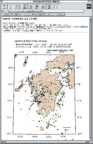
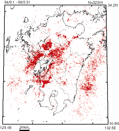
Earthquakes in the Kyushu Island fall into two groups. One is crustal earthquakes which occurr shallower than 30 km in depth, and the other is those associated with subduction of the Philippine Sea plate into the mantle under the Kyushu Island.
The zone extending from Beppu through Kuju, Aso, and Unzen volcanoes to the Sea of Amakusa, called "Beppu-Shimabara graben", and the belt along the coast of the Ariake and the Yatsushiro Sea are both seismically very active.
Moreover, the Satsuma region, northwest of the Kagoshima Prefecture, recently becomes very active with a few hazardous inland earthquakes of magnitudes around 6.
Focal mechanisms of crustal earthquakes in the Beppu-Shimabara graben indicate north-south or northwest-southeast extension of the crust of the Kyushu Island.
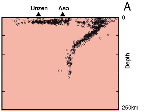
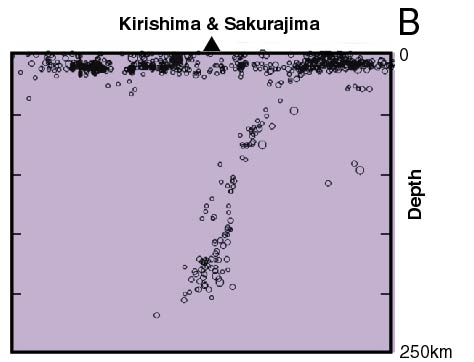
The earthquakes associated with subduction of the Philippine Sea plate occur in a seismic zone inclining steeply from the Sea of Hyuga toward the deep mantle beneath the Kyushu Island. This distribution of hypocenters seems to show the aspect of the subducting Philippine Sea plate in the mantle.
Big earthquakes of magnitudes around 7 occur once a decade in the Sea of Hyuga, which often accompanies tunamis.

Pubulication of seismic information of the Kyushu area through Internet


Distribution of epicenters shallower than 30 km in depth


Distribution of all epicenters occurred in 1992 - 1994


Cross section of Kyushu Island in the direction of Philippine Sea plate subduction
(Epicenters in the A region of the above diagram: the northern half of the Kyushu Island)

Solid triangles indicate active volcanoes. The sinking Philippine Sea plate arrives at 100 - 150 km in depth just under the volcanic front on which Kuju, Aso, Kirishima and Sakurajima volcanoes lie.
Hypocenters distribute along the sinking Philippine Sea plate.


Cross section of Kyushu Island in the direction of Philippine Sea plate subduction
(Epicenters in the B region of the above diagram: the southern half of the Kyushu Island)

Solid triangles indicate active volcanoes. The sinking Philippine Sea plate arrives at 100 - 150 km in depth just under the volcanic front on which Kuju, Aso, Kirishima and Sakurajima volcanoes lie.
Hypocenters distribute along the sinking Philippine Sea plate.


Top Determination of epicenters and publication through the Internet

Earthquake wave forms collected by communication satellites are automatically or manually analyzed for their hypocenters, initiation times and magnitudes.
They are reported to the Coordinating Committee for Earthquake Prediction and the Coordinating Committee for Volcanic Eruption Prediction. Furthermore, they are used for seismological and volcanological studies.
Processed seismic data are now open to the public through the Internet which makes remarkable progress in recent years.
You can also simultaneously see seismic data published through the Internet from other universities and disaster prevention organizations.
Information on seismicity in Kyushu is automatically renewed every 30 minutes on the website of SEVO (URL: http://www.sevo.kyushu-u.ac.jp/%7Ehypo/hypomap/).


Top page of Part 4 Previous page Next page