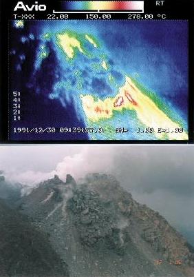
4 - 8 | Thermal imagery |
Top of Part 4
Previous p. |
Material at a certain
temperature radiates
infrared-ray
which has an energy
proportional to
the fourth power of
its absolute temperature
(an temperature which
fixed its origin
at 273 degrees centigrade
below zero).
By making use of this, we can get a distribution map of ground surface temperatures when we observe a spectrum of infrared-ray radiated from some area. An airplane is commonly employed for the observation of a large area in a short time. The ground temperature distribution map obtained in this way is called an aerial infrared-ray image. A surface temperature of an active volcano is closely related with the volcanic activity. Therefore, an aerial infrared-ray image is useful for immediate grasp of the present state of volcanic activity. Discovery of a new abnormally high temperature area may lead to the prediction of a volcanic eruption of which surface activity is not yet exposed. In cooperation with the Self-Defence Forces, SEVO has kept taking aerial infrared-ray images of the summit area from a helicopter during the period of eruption of Unzen volcano. |
Surface temperature
distribution map
of the growing lava dome
(the sixth lava lobe) High temperature part from the tip of dome to the smooth slope represents the collapse of the lava dome. At the summit of the dome, there is another high temperature part due to the extrusion of new fresh lava. |
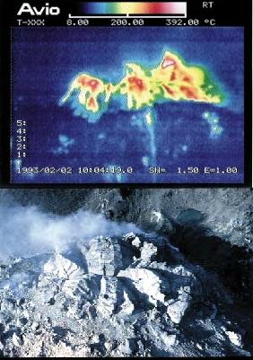
Growth of the tenth lava lobe
Three high temperature parts correspond to petal-shaped lava lumps, respectively. (This picture is taken from the north). |
|
Pyroclastic flow
The temperature inside the flow is estimated to be more than 500 degrees centigrade. |
||
An aerial infrared-ray
imaging apparatus
This is a non-contact imaging device to measure a temperature of a material by analyzing a spectrum of infrared-ray radiated from it. Its surface temperature distribution map is shown on a monitor television in color. |
Top page of Part 4 Previous page |